GIS SOFTWARE
DEVELOPMENT
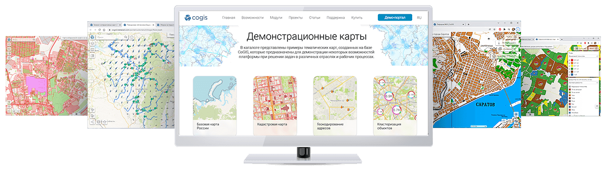
Отечественная геоинформационная платформа для создания и публикации картографических веб-приложений с возможностью редактирования и анализа пространственных данных. Обеспечивает регулируемый доступ к пространственной информации через персональные компьютеры и мобильные устройства с возможностью редактирования и анализа геоданных.
С 2001 года наша компания является ведущим разработчиком программного обеспечения в области геоинформационных технологий в России. Обладая широким спектром компетенций, необходимых для реализации высокотехнологичных ГИС-проектов, «Дата Ист» решает задачи любой сложности, начиная с создания мобильных картографических приложений и заканчивая системами обработки пространственных данных на корпоративном уровне.

Эффективные инструменты для работы с пространственными данными и картами онлайн. Загрузите данные, задайте параметры и скачайте готовый результат.
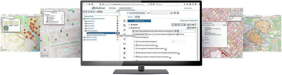
Специализированное масштабируемое программное решение, созданное и функционирующее в экосистеме отечественной геоинформационной платформы CoGIS. Предназначено для решения задач муниципального управления и реализации сценариев «умных городов».

Облачная геоинформационная система CityCloud стала лауреатом национальной премии IT-решений «Цифровые вершины» в номинации «Опора цифровизации». Конкурс российских разработчиков проводился под эгидой Министерства цифрового развития, связи и массовых коммуникаций РФ.
Наша платформа CoGIS завоевала третье место в Национальном конкурсе ИТ-решений «ПРОФ-IT. Инновация» в номинации «Пространственные данные». Конкурс был организован с целью оказания содействия российским ИТ-разработчикам в продвижении своих продуктов и стимуляции увеличения вложений в лучшие отечественные решения в сфере ИТ.
Созданные нами информационные системы, программные продукты, мобильные и веб-приложения широко используются в сфере государственного и муниципального управления, горнодобывающей и нефтегазовой промышленности, транспорте и энергетике, геологии, геодезии, лесном хозяйстве и в целом ряде других отраслей.
ГИС-интеграция
Создание инфраструктуры пространственных данных для повышения эффективности решения производственных, управленческих и аналитических задач предприятия, а также для создания, хранения, каталогизации и ведения геоданных.

Подбор программного обеспечения под нужды заказчика, поставка и внедрение базового ПО Esri и специализированных решений «Икс Тулс» и «Дата Ист»

Авторизованный учебный центр оказывает помощь в освоении программных продуктов Esri

Предоставление полного комплекса услуг по использованию геоинформационных технологий при автоматизации ключевых бизнес-процессов предприятия
Геоинформационный портал Мэрии Новосибирска
Комплексная технологическая платформа, объединяющая систему создания, хранения, каталогизации геоданных на территорию города, служебный портал для геоинформационного обеспечения деятельности департаментов мэрии, а также публичный портал для информирования и взаимодействия с жителями города.
Международное, национальное и региональное сотрудничество

Член ассоциации содействия развитию информационных технологий

Участник программы развития научно-производственного кластера

Резидент Технопарка Новосибирского Академгородка

Региональный партнер РГО

На Бизнес-партнерской конференции Esri «Дата Ист» была выбрана победителем в номинации Turning Pro – за успешный опыт миграции программных продуктов и сервисов на платформу ArcGIS Pro.
Курс на ArcGIS Pro
Сегодня все больше пользователей ArcMap активно осваивают новую платформу ArcGIS Pro и, конечно же, хотят иметь возможность продолжать использовать привычные инструменты и сервисы в этой новой среде. Услуга переноса пользовательских приложений на ArcGIS Pro SDK с каждым днем становится все более востребованной - самое время переходить на новые технологии вместе с нами!

Новое поколение в семействе продуктов ArcGIS
Новый настольный продукт от Esri, входящий в состав ArcGIS for Desktop, который позволяет эффективно управлять сложными проектами благодаря возможности работать со множеством карт, компоновок и инструментами анализа в хорошо организованной среде. Эта платформа предлагает множество инструментов для визуализации, анализа, компиляции и распространения ваших пространственных данных на новом уровне.

Признанный лидер в области миграции ПО
«Дата Ист» имеет успешный опыт миграции и модернизации пользовательских приложений и внутрикорпоративных решений Esri, Elsevier и других компаний на новую технологическую платформу ArcGIS Pro.